Maps of California Athabascan Territories

Back to Cahto Home Page


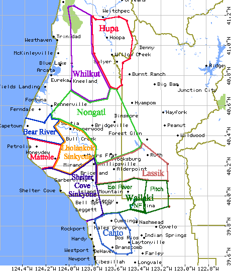
Clickable Map of California Athapaskan Language Areas

(under construction--only Cahto and Wailaki areas even started yet)


Map of Southern California Athabaskan territory (with some Cahto placenames) arranged by USGS 7.5min. quadrangle map names

Note that no village sites are included on this publicly available map to keep the vandals and trophy hunters from finding village sites.

Ettersburg (-123.9375,40.1875) Miranda (-123.8125,40.1875) Ft. Seward (-123.6875,40.1875) Alderpoint (-123.5625,40.1875) Zenia (-123.4375,40.1875) Shannon Butte (-123.3125,40.1875)
Briceland (-123.9375,40.0625) Garberville (-123.8125,40.0625) Harris (-123.6875,40.0625) Jewett Rock (-123.5625,40.0625) Lake Mountain (-123.4375,40.0625) Long Ridge (-123.3125,40.0625)
Bear Harbor (-123.9375,39.9375) Piercy (-123.8125,39.9375) Noble Butte (-123.6875,39.9375) Bell Springs (-123.5625,39.9375) UpdeGraff Ridge (-123.4375,39.9375) Mina (-123.3125,39.9375)
Mistake Point (-123.9375,39.8125) Hales Grove (-123.8125,39.8125) Leggett (-123.6875,39.8125) Tan Oak Park (-123.5625,39.8125) Iron Peak (-123.4375,39.8125) Covelo West (-123.3125,39.8125)
Westport (-123.8125,39.6875) Lincoln Ridge (-123.6875,39.6875) Cahto Peak (-123.5625,39.6875) Laytonville (-123.4375,39.6875) Dos Rios (-123.3125,39.6875)
Inglenook (-123.8125,39.5625) Dutchman's Knoll (-123.6875,39.5625) Sherwood Peak (-123.5625,39.5625) Longvale (-123.4375,39.5625) Willis Ridge (-123.3125,39.5625)
Ft.Bragg (-123.8125,39.4375) Noyo Hill (-123.6875,39.4375) Northspur (-123.5625,39.4375) Burbeck (-123.4375,39.4375) Willits (-123.3125,39.4375)